Trail Map, Distance & Conditions
Technical Breakdown of the Byron Glacier Trail Terrain
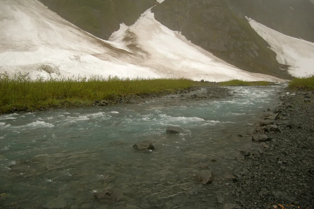
The Byron Glacier Trail deceives many hikers with its short 2.8-mile round-trip distance. A quick glance at standard trail summaries suggests a casual stroll through the woods, yet the reality on the ground demands a far more technical understanding of the landscape. The Chugach National Forest trail system categorizes this route as easy, a rating attempting to classify two drastically different hiking environments. The initial 0.9 miles accommodates all skill levels on a heavily groomed surface. The final half-mile forces visitors into a rugged alpine scramble over unstable rock deposits left behind by centuries of glacial retreat. Understanding the precise topography, the shifting weather patterns, and the distinct geological zones of the Portage Valley ensures you bring the right gear and the correct mindset. Katabatic winds plunging off the surrounding icefields alter the valley’s microclimate by the hour, dropping temperatures rapidly even on clear summer afternoons. This guide deconstructs the trail mile by mile, providing the hard data required to navigate the moraine safely.Trail Snapshot: Quick Reference
| Total Distance | 1.4 miles (2.25 km) round-trip |
| Elevation Gain | Approximately 175–200 feet |
| Difficulty Rating | Easy to Moderate (Family-friendly start, rocky finish) |
| Estimated Time | 45 minutes to 1.5 hours |
| Primary Terrain | Maintained gravel transitioning to glacial moraine |
| Trailhead Coordinates | 60.7758° N, 148.8256° W |
The Trail Experience: From Path to Scramble
Hikers begin their trek at the primary staging area just off Portage Valley Road. For specific driving directions and parking lot capacity details, consult the How to get to Byron Glacier Trail guide. The moment you leave the pavement, the route enters a dense canopy of alder and black cottonwood trees. This section features a wide, hard-packed gravel surface engineered by the Forest Service to resist heavy rainfall and snowmelt. The grade remains almost entirely flat, allowing visitors to maintain a brisk pace while taking in the views of the surrounding peaks. At the 0.9-mile mark, the manicured gravel terminates at a small viewing bench. The infrastructure vanishes entirely. From this point forward, the environment shifts into a raw, unpredictable glacial valley. Hikers step off the dirt and onto a vast field of graywacke and shale. These jagged rocks vary in size from small pebbles to massive boulders the size of compact cars. The glacier deposited this debris—known as a terminal moraine—as it slowly receded up the mountain over the last century. Navigating the moraine requires constant visual assessment. The rocks shift under body weight. Frost heaving and frequent rockfalls continuously alter the path, meaning no two hikes through this final segment are identical. The narrow rocky sections cannot accomodate large hiking groups walking side-by-side. Single-file movement becomes mandatory to avoid kicking loose debris onto trailing companions. This is the exact type of unstable environment you want to bring sturdy trekking poles for.Detailed Elevation Profile
The altimeter reading for this hike registers a minimal 100-foot climb, but the distribution of that elevation gain defines the physical challenge. The first 0.9 miles gain less than 40 feet in total. The path follows the natural, gentle contour of Byron Creek, running parallel to the milky, turquoise water tainted with glacial flour. The remaining 60 feet of elevation gain occurs entirely within the final 0.5 miles. As you push closer to the ice base, the moraine piles up in steep, overlapping ridges. You must step up and over large boulders, engaging stabilizing muscles in your core and ankles. The incline creates blind spots where the trail seems to disappear behind mounds of shattered stone.Navigating the Glacier Base
The trail officially ends at the edge of the boulder field, providing a direct sightline to the ice. Byron Glacier is an active hanging glacier, meaning vast chunks of ancient ice cling to the sheer rock face high above the valley floor. Gravity and warming temperatures cause this ice to fracture and plummet without warning. Avoid advancing past the established rock barrier, as falling ice turns into deadly shrapnel upon impact.Connectivity & Navigation Warning
Cellular service drops to zero miles before you reach the trailhead. The steep rock walls of the Portage Valley block all incoming signals. You must download offline maps via platforms like AllTrails or Gaia GPS before leaving Anchorage or Girdwood. Relying on a live internet connection to view topographical data will leave you completely blind in the field.Real-Time Trail Conditions & Seasonal Fluctuations
The physical state of the trail changes drastically depending on the month. The United States Forest Service monitors the area, and it is imperative to check the official USFS Chugach National Forest alerts page for active closures, maintenance delays, or washed-out bridges before your departure. Avalanche debris often covers the valley floor well into late May. Hikers arriving in teh early spring must traverse hard-packed snow bridges that span across Byron Creek. As the melt accelerates into June, these snow bridges become hollow and incredibly dangerous. Stepping on a compromised snow bridge can result in a sudden drop into the freezing, fast-moving water below. Snow and avalanche debris often persist into late summer or year-round, rather than fully receding by mid-July. Heavy summer rainstorms turn the exposed transition zones into thick, slick mud. The low depressions right before the moraine field gather standing water, requiring waterproof footwear to bypass comfortably. For a more comprehensive breakdown of weather patterns and month-by-month accessibility, review our Seasonal Guide: Summer vs. Winter.Ranger Insight: Never assume a clear sky in Anchorage guarantees dry conditions in Portage Valley. The mountains funnel coastal moisture directly into the gorge, creating localized rain showers that turn dry rock fields into hazardous, slippery obstacles in minutes.
Gear Protocols and Safety Integration
Proper equipment mitigates the inherent risks of the Chugach Mountains. Standard running shoes lack the torsional rigidity required to protect your feet on the jagged graywacke. Stiff-soled hiking boots with deep lugs provide the necessary traction when moving across wet rocks. Layering remains critical regardless of the season. The temperature near the ice base routinely sits ten to fifteen degrees colder than the parking lot. Pack a windproof shell to combat the katabatic drafts. Beyond clothing, wildlife preparedness is non-negotiable. The thick alder brush lining the first half of the trail provides prime foraging grounds for black and brown bears. Carrying EPA-approved bear spray and making consistent noise while hiking prevents surprise encounters. Read our detailed breakdown on Understanding Bear Country Etiquette to learn how to deploy deterrents effectively. If you prefer not to manage the logistics of navigation, driving, and wildlife spotting on your own, guided excursions offer a seamless alternative. Booking a Glacier & Wildlife Discovery Tour directly from Anchorage takes you to nearby Portage Glacier via boat and the Alaska Wildlife Conservation Center, avoiding trail logistics entirely. You can explore more outfitter options on our Tickets & Tours page.Essential Resources & Official Data
To build a complete itinerary, rely on primary data sources and strict adherence to local regulations. The National Weather Service Anchorage provides localized forecasts crucial for anticipating sudden rainstorms or high wind events in the valley. For geological context regarding the shrinking ice mass, the USGS Alaska Science Center tracks the historical retreat data of the region’s glaciers.- Ice Caves & Avalanche Safety: A sobering, mandatory guide explaining the severe risks of approaching the unstable ice formations and the hidden dangers of the valley’s snowpack.
- Safety Essentials for Alaska Hiking: A broad overview covering satellite communication devices, emergency shelter tactics, and surviving unpredictable coastal weather.
- Visitor Rules & Guidelines: Official ‘Leave No Trace’ principles, commercial permit regulations, and the strict pet policies enforced by the Forest Service.
- Best Stops Along the Seward Highway: Plan your drive down from Anchorage by mapping out the safest pull-offs, scenic viewpoints, and historical markers along the Turnagain Arm.
- Glacier Science & Wildlife: Discover the unique biology of the ice worms that inhabit the glacier and understand the geological forces shaping the moraine you walk across.
Preparation separates a rewarding wilderness experience from a miserable, dangerous ordeal. Treat the short mileage with the respect a rugged alpine environment commands. Download your maps, lace up the right boots, and enjoy one of the most immediate, visceral glacier encounters available in Southcentral Alaska.