Seasonal Guide: Summer vs. Winter
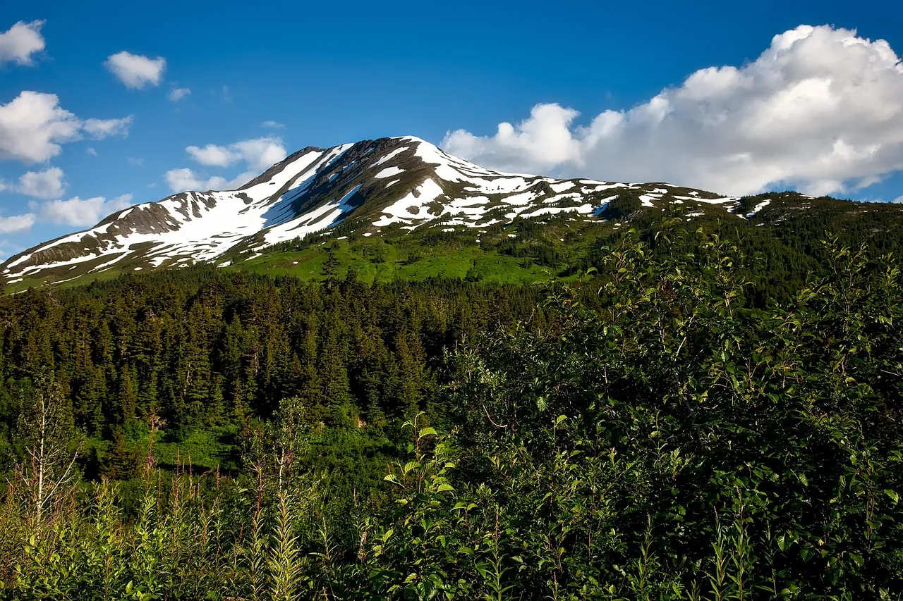
Portage Valley operates on two completely different chronological rhythms. At roughly 60.77° North, 148.81° West, this specific slice of the Chugach National Forest experiences dramatic maritime subarctic climate swings that redefine the physical geography every few months. The Byron Glacier Trail acts as a barometer for these extreme shifts. A casual, family-friendly gravel walk in late July transforms entirely into a high-alpine mountaineering scenario by late January. Visitors must understand the meteorological realities of this terrain to safely plan their arrival. The massive hanging glacier suspended above the valley dictates the environmental risk level throughout the year. We break down the absolute logistical necessities for planning your timeline, ensuring your preparation matches the demands of the Alaskan wilderness.
The Summer Window (June–August)
The June through August window brings complete accessibility to the region. The 2.8-mile round-trip trail sheds its deep snowpack by late June, revealing a well-maintained, relatively flat path leading directly to the rocky moraine near the ice base. Families, casual hikers, and landscape photographers find an environment perfectly suited for unhurried exploration. This period provides immense daylight—stretching up to 19 hours around the summer solstice—allowing for late-evening excursions without the pressure of a rapidly setting sun. You can spend hours navigating the massive glacial erratic rocks in the bouldering fields right below the ice flows.
Wildlife activity peaks during this brief warm season. Sockeye and silver salmon runs in nearby Portage Creek draw brown and black bears down from higher mountain elevations to feed. Carrying EPA-approved bear deterrent is a non-negotiable requirement for anyone stepping onto the path. Review our comprehensive visitor rules for exact specifications on trail etiquette and wildlife spacing. High-season travelers often maximize their understanding of the local ecology by pairing this hike with a broader Glacier & Wildlife Discovery Tour, letting professional guides handle the complex bear-country navigation.
The USDA Forest Service maintains the primary trailhead facilities during these months. Restrooms are serviced regularly, and clear interpretive signage remains visible. The lack of snow means you can observe the fascinating micro-biology of the area, including the famous ice worms that inhabit the glacier’s surface. Dive into our glacier science & wildlife page to understand the unique biology surviving in this extreme habitat.
The Winter Wonderland (October–April)
October through April fundamentally alters the geography of Portage Valley. The established gravel path vanishes beneath feet of packed powder, rime ice, and wind-blown drifts. Backcountry skiers, split-boarders, and snowshoers claim the territory. The landscape shifts from a welcoming hiking route to a demanding wilderness environment requiring specialized floatation gear. The hanging glacier above drops massive seracs—house-sized blocks of ice—creating a persistent and lethal avalanche hazard across the approach zone. Entering this terrain requires absolute competence with snowpack assessment.
Carrying a 457 kHz avalanche transceiver, a carbon fiber probe, and an aluminum backcountry shovel is mandatory if you plan to venture beyond the immediate tree line. We detail these exact topographical hazards extensively in our ice caves and avalanche safety guide. The freeze-thaw cycles compromise the structural integrity of the ice formations, making the approach highly volatile, which is something you must be prepared for. Those unfamiliar with assessing snow stability should strongly consider hiring local experts or joining a structured Winter – Wildlife & Turnagain Arm Tour to safely experience teh valley floor.
Logistics become significantly more complicated. Snow tires or a heavy four-wheel-drive vehicle are required just to reach the trailhead parking lot. Plowing operations along Portage Glacier Road are often delayed following heavy Pacific storm cycles. You must constantly monitor the Chugach National Forest Avalanche Information Center for real-time risk assessments before loading your vehicle.
Weather & Safety Data
The early months of the year present the most significant logistical hurdles for independent travelers. You are operating in a highly compressed time frame dictated by solar exposure and plummeting temperatures. Understanding this data allows you to optimize your outdoor window.
| Month | Avg Temp (F) | Daylight | Primary Hazard |
|---|---|---|---|
| January | 15° | 6h 30m | Extreme Cold / Low Visibility |
| February | 22° | 8h 45m | Deep Snowpack / Avalanches |
| March | 28° | 11h 15m | Changing Snow Conditions |
| April | 38° | 14h 00m | Ice-Fall / Rapid Melting |
January brings punishing lows around 15°F and a mere six and a half hours of usable daylight. You must execute your plan swiftly, carrying headlamps equipped with lithium batteries, as standard alkaline cells die rapidly in sub-freezing temperatures. February deepens the overall snowpack, creating optimal conditions for snowshoeing, with temperatures marginally climbing into the low twenties. March is widely considered the premier month for winter sports in the Chugach range; the daylight expands past eleven hours, and the snow conditions often stabilize.
April introduces the chaotic spring transition. Averages hit 38°F, causing rapid melting, deep slush, and heavy mud along the lower elevations. The risk of catastrophic ice-fall from the upper hanging glacier peaks during these April temperature spikes as the structural bonds holding the ice to the rock face weaken. Always verify the most current trail map and conditions before finalizing your itinerary.
Choosing Your Time: A Traveler’s Matrix
Your skill level and your tolerance for geographical adversity should dictate exactly when you book your flight to Alaska. The Byron Glacier trail offers entirely different reward systems depending on the month. The shoulder seasons—May and September—are particularly deceptive. They lack the easy walking conditions of mid-summer and the pristine snowpack of mid-winter.
“The shoulder seasons of May and September are beautiful but entirely unpredictable. Expect knee-deep mud, lingering slick ice, and rapidly changing weather patterns pulling in off the Turnagain Arm.”
- For Beginners & Families: Target July and August. The trail is fully maintained, entirely snow-free, and requires zero technical equipment. Standard hiking boots, a lightweight rain shell, and bear spray are sufficient. Combine the hike with other best stops along the Seward Highway for a full day of low-stress sightseeing.
- For Photographers: Late June offers the midnight sun, providing endless hours of golden-light photography against the glacial ice. September brings stunning autumnal colors to the brush of Portage Valley, though the weather will be wet.
- For Adventure Seekers: February and March provide the premier conditions for backcountry snowshoeing. The snow bridges over the creeks are generally solid, allowing for deeper exploration. You will need extensive Alaska hiking safety gear, including synthetic insulation and avalanche rescue equipment.
- For Guided Experiences: If you lack the necessary technical skills for glacier country, rely on professionals. Review our tickets and tours portal to secure a spot with certified mountain guides who handle all the logistical friction.
Logistics and Transit Adjustments
Seasonal shifts dictate your transportation strategy just as heavily as your clothing choices. In summer, any standard rental sedan can make the drive down the Seward Highway from Anchorage and navigate Portage Glacier Road with ease. In winter, you are dealing with black ice, high winds whipping off the inlet, and heavy snowfall. For comprehensive routing details, study our guide on how to get to Byron Glacier Trail.
Before leaving your hotel in Anchorage or Girdwood, cross-reference multiple official meteorological sources. Check the National Weather Service Anchorage for incoming maritime storm warnings. Verify the road surface conditions via the State of Alaska’s 511 traffic portal. The Chugach Mountains generate their own localized weather systems, meaning the clear skies over your hotel can translate to sideways sleet at the trailhead.
Proper planning transforms an intimidating subarctic environment into an accessible wilderness experience. Match your technical skills to the appropriate season, carry the requisite emergency gear, and respect the immense power of the hanging ice above Portage Valley.